





/NOT FOR DISSEMINATION IN THE UNITED STATES OR FOR DISTRIBUTION TO U.S. WIRE SERVICES/
Highlights:
- UAV magnetic and LiDAR surveys now underway at Munro Lake to map the faults and contacts that are favourable targets for gold mineralization
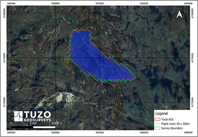
- Approximately 520 line-kilometres on 30-metre flight lines with 300-metre tie lines, covering 11.6 square kilometres along the 7-kilometre mineralized trend
- Flown by Chase Wood, P.Geo., M.Sc., of TUZO GeoSurveys Corp., whose M.Sc. thesis mapped the adjacent Seabee/Santoy gold complex**. Chase will apply his local expertise by also mapping the orientation of the gold mineralization on surface to guide the 2026 drilling
- Survey data to be integrated with historical drilling and surface grab samples* to prioritize additional drill-ready targets
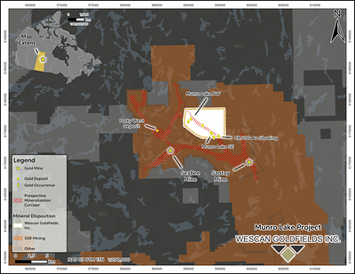
- Munro Lake lies 7 kilometres northeast of SSR Mining’s Seabee mine and mill complex, Saskatchewan’s only producing gold operation**
SASKATOON, SK, Sept. 16, 2026 /CNW/ — Wescan Goldfields Inc. (TSXV: WGF) (FSE: W17A) (“Wescan” or the “Company“) is pleased to announce that high-resolution unmanned aerial vehicle (UAV) magnetic and LiDAR surveys are now underway at its Munro Lake Project in northern Saskatchewan. The surveys are designed to map the faults and contacts that are favourable targets for gold mineralization at the project and to refine drill targets along the 7-kilometre mineralized trend ahead of the Company’s 2026 drill campaign.
Gold at Munro Lake occurs in quartz veins developed along and adjacent to structural breaks, and the Company considers the intersections, flexures and dilational jogs along those breaks to be the most prospective settings for wider or higher-grade mineralization. High-resolution magnetics resolve these structures through the offset, truncation and alteration of magnetic stratigraphy, while LiDAR-derived terrain modelling images their surface expression as topographic lineaments, breaks in slope and outcrop patterns beneath variable overburden. Mapping that structural framework across the property is the principal objective of the survey.
The magnetic survey also carries the potential to detect mineralized structures directly. Gold-bearing quartz veins at Munro Lake commonly contain pyrrhotite, a magnetic iron sulphide, which may produce discrete magnetic responses over individual veins in addition to the broader structural signature resolved by the survey.
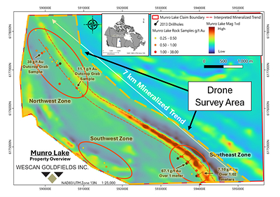
The magnetic survey is being flown on 30-metre flight lines with 300-metre tie lines oriented northeast–southwest, broadly perpendicular to the interpreted trend of mineralization, for a total of approximately 520 line-kilometres. Coverage totals approximately 11.6 square kilometres (1,160 hectares) in a single contiguous block extending along the 7-kilometre mineralized trend and encompassing the Northwest, Southwest and Southeast zones (Figure 1); the survey area and flight line layout are shown in Figure 2. Drone-based magnetics provide much tighter line spacing and lower flight heights than conventional fixed-wing or helicopter surveys, yielding a level of structural detail those platforms cannot resolve.
The surveys are being flown by TUZO GeoSurveys Corp. of Calgary, Alberta, under the direction of Chase Wood, P.Geo., M.Sc., the firm’s Chief Executive Officer. Mr. Wood’s M.Sc. research was completed on the adjacent Seabee/Santoy gold complex and is titled Structural study of the auriferous Santoy shear zone, northeastern Glennie domain, Saskatchewan (2016). His familiarity with the regional geology and the structural style of the Seabee/Santoy corridor is expected to aid in the rapid interpretation of the Munro Lake data and in translating geophysical anomalies into practical drill targets**.
In conjunction with the airborne surveys, Mr. Wood will complete limited structural mapping in the southeast zone, where Wescan’s 2013 diamond drilling intersected 67.1 g/t gold over 1.00 metre*** in drill hole EXML-002 and 7.1 g/t gold over 1.02 metres*** in EXML-001 (see Company news release dated June 17, 2013). The mapping will measure the strike and plunge of the gold-bearing quartz veins exposed at surface in this area. Establishing the orientation and plunge of the vein system is expected to inform the siting, azimuth and dip of holes in the Company’s upcoming 2026 drill campaign, which is intended to test the extent of the 2013 mineralization down-plunge and along strike.
When integrated with historical drill holes, surface grab samples*, and geological mapping, these datasets will allow the Company to refine its structural interpretation, prioritize drill-ready targets along the trend, and more effectively position future drill holes to test down-plunge extensions and structurally dilated zones. This workflow bridges the gap between broad reconnaissance and precise drill planning, helping Wescan lower exploration risk and focus capital on the highest-confidence targets ahead of subsequent drilling phases.
|
* Surface grab samples, by their nature, are selective samples and may not represent underlying mineralization. |
|
** Exploration on adjacent or nearby properties does not guarantee that similar mineralization exists on a specific property. |
|
*** True thickness unknown. |
Qualified Person
The scientific and technical information contained in this news release has been reviewed and approved by John Shmyr, P.Geo., of Dahrouge Geological Consulting Ltd., a registered member of the Association of Professional Engineers and Geoscientists of Saskatchewan. Mr. Shmyr is a “Qualified Person” as defined by National Instrument 43-101 – Standards of Disclosure for Mineral Projects (“NI 43-101”). Mr. Shmyr has verified the data disclosed in this news release and consents to the inclusion of the matters based on his information in the form and context in which it appears.
About Wescan Goldfields Inc.
Wescan Goldfields Inc. is a Canadian junior exploration company focused on the exploration and development of gold projects in northern Saskatchewan. The Company holds a 100% interest in four gold projects: the Munro Lake Project, located in the Pine Lake greenstone belt adjacent to the Seabee/Santoy gold camp; and, in Saskatchewan’s historic La Ronge Gold Belt, the Jojay Lake Project, which hosts the Jojay gold deposit, the Fork Lake Project, which hosts the past-producing Jasper gold mine, and the recently acquired Lindsay Lake Project.
The Jojay gold deposit is the subject of a 2010 NI 43-101 compliant mineral resource estimate completed by A.C.A. Howe International Limited, comprising an Indicated Resource of 420,000 tonnes grading 3.7 g/t gold and an Inferred Resource of 630,000 tonnes grading 4.3 g/t gold (at a 2.0 g/t gold cut-off). The Jasper gold mine was operated by Cameco Corporation in the early 1990s and produced approximately 155,000 tons at a grade of approximately 18.5 g/t gold prior to its closure. Shares of Wescan trade on the TSX Venture Exchange under the symbol “WGF”.
Important Information Regarding Forward-Looking Statements
Information set forth in this news release may contain forward-looking statements. Forward-looking statements are statements that relate to future, not past, events. Forward-looking statements are often, but not always, identified by the use of words such as “seek,” “anticipate,” “plan,” “continue,” “estimate,” “expect,” “may,” “will,” “intend,” “could,” “might,” “should,” “believe,” “scheduled,” “to be,” “will be” and similar expressions. Forward-looking statements in this news release are based upon the opinions and expectations of management of the Company as of the effective date of such statements. Although the Company believes that the expectations reflected in such forward-looking statements are based upon reasonable assumptions, it can give no assurance that those expectations will prove to have been correct. Forward-looking statements in this news release include, but are not limited to, statements relating to the Company’s corporate strategy; the Munro Lake Project and its mineralization potential; the anticipated benefits and outcomes of the UAV magnetic and LiDAR surveys; the refinement of drill targets and the timing and scope of future drilling; and the Company’s objectives, goals, or future plans with respect to its exploration programs. These forward-looking statements are subject to numerous risks and uncertainties, including those described in the publicly filed documents of the Company, available on SEDAR+ at www.sedarplus.ca. Such risks and uncertainties could cause actual outcomes to differ materially from those anticipated or implied by such forward-looking statements. Accordingly, readers should not place undue reliance on the forward-looking statements contained in this news release, and such forward-looking statements should not be interpreted or regarded as guarantees of future outcomes.
Forward-looking statements are based on the Company and its management’s good-faith assumptions relating to the financial, market, regulatory, and other relevant environments that will exist and affect the Company’s business and operations in the future. The Company does not give any assurance that the assumptions on which forward-looking statements are based will prove to be correct, or that the Company’s business or operations will not be affected in any material manner by those or other factors not foreseen or foreseeable by the Company or management, or beyond the Company’s control.
The forward-looking statements contained in this news release are made as of the date hereof, and the Company does not undertake any obligation to update or revise any of the included forward-looking statements, except as required by applicable securities laws in force in Canada. The forward-looking statements contained herein are expressly qualified by this cautionary statement.
Neither the TSX Venture Exchange nor its Regulation Services Provider (as that term is defined in the policies of the TSX Venture Exchange) accepts responsibility for the adequacy or accuracy of this release.

SOURCE Wescan Goldfields Inc.
Source: https://rss.releasewire.net/feeds/release/20260916C0568